Previous Chapter Return to Tony's Home Page
Day 2 Saturday 24th April 2004
Carnon
Downs to Boscastle Youth Hostel
I had
asked for breakfast at 7.30 this morning. I
had also requested a slightly smaller breakfast although the intention was to
stick to the full English while I was cycling.
It may not be too good for the cholesterol but it sure gets you off to a
good start and delays the 11’s break which for some reason, more often than
not, happens around 10. The landlady
told me this morning, that the vicar and lady friend had returned in the small
hours of the night – I hadn’t heard them come in – they had been out for a
meal with friends. The landlady was
doing her WI market but she wasn’t in a rush – there was no hope of getting
the vicar up early after the previous nights revelry and she had arranged for a
friend to man the stall until she got there.
These markets are held on the first Saturday in the month at the church
hall for anyone interested.
The
weather this morning was very low cloud – almost a mist – with a fine
drizzle falling. I was going to pick
up the CTC route in
Truro
– about 4 miles down the main A39 road. For
some of the route there was a cycle path – for the remainder I was able to
follow a narrow lane which was at one time the old main road into
Truro
. By the time I got to the city the
drizzle had cleared.
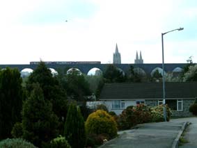 The
town of Truro is dominated by two landmarks – the Cathedral and the Railway viaduct.
Planning rules in the 19th century were not the same as they
are now - they never would have obtained permission to build the railway viaduct
if that were the case. I tried to
pick up the CTC route from the Cathedral but the central area is heavily
pedestrianised and signposts to Shortlanesend and Idless did not appear on my
horizon. My attempts to follow the
river to Idless resulted in my finding
a cycle track under the viaduct
alongside the west bank of the river.
The
town of Truro is dominated by two landmarks – the Cathedral and the Railway viaduct.
Planning rules in the 19th century were not the same as they
are now - they never would have obtained permission to build the railway viaduct
if that were the case. I tried to
pick up the CTC route from the Cathedral but the central area is heavily
pedestrianised and signposts to Shortlanesend and Idless did not appear on my
horizon. My attempts to follow the
river to Idless resulted in my finding
a cycle track under the viaduct
alongside the west bank of the river.
This looked very
promising until I got to the far end of the track and discovered it was a
footpath with a narrow kissing gate at the far end which proved difficult to get
the bike through. I ended up in a
small estate of bungalows on a hill overlooking the city and was able to get a
good photo of a train crossing the viaduct with the cathedral behind.
Carrying on up the hill, I asked a man who was tending his garden, the
right way to Idless. Just round the
corner and I was on the correct road again.
As so often is the case, as soon as you stop to chat to someone they
begin to relate the days when they rode their bike and the enjoyment they had.
He wished he could still do it.
Because
I hadn’t been on the CTC route, I had put the typed CTC direction sheet in
between the folds of my transparent map case – it seemed quite safe in here
and was easy to extract if required. No
zips to undo or straps to release. I
was still able to read the map like this. The
light wasn’t so good this morning and I was struggling to read the smaller
place names on the map without my glasses on.
Perhaps this is why I got lost in Truro! Somehow, somewhere on the road to
Idless the typed instruction sheet must have fallen out, but I was sure that I
had read them in the past mile or even less.
Time to backtrack maybe, as this sheet contained directions for the next
20 miles. Not a disaster if lost, as
the sheets for the remainder of the trip were safety stored away.
I cycled back along the road and there they were lying in the middle of
the lane no more than ½ mile from where I had turned round.
No cars had used the road since I had passed and they hadn’t ended up
in the wet verge. I turned
round and started in the right direction again.
Near
St. Newlyn East I happened across the Lappa
Valley
railway. This is a narrow gauge
railway and although I am not particularly interested in trains I thought I
might be able to get a cup of tea for my 11’s.
They looked as though they had just opened for the day - the cup of tea
was provided and the loos came in handy. I
took a photo of Zebedee – one of the trains – which I hope was not in the
habit of jumping off the tracks.
The
section of the route from St Columb Major until just after Wadebridge uses the
main A39. 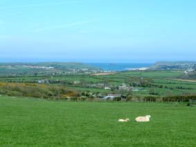 I wasn’t looking forward
to 12 miles of main road but the alternative is to go up onto the moor to the
east. It wasn’t too bad in the
end. I avoided some of this road by
going through the village
of
St Columb
and later on I deviated into Wadebridge itself rather than take the bypass.
The main road for the most part has a dotted white safety line running
along the verge about 2 ft from the edge of the tarmac and although not a proper
cycle lane, afforded some protection from the passing traffic. The
main problem with these lanes is that they get full of grit and other debris as
the traffic hardly ever uses them and road sweepers are few and far between.
Just outside Wadebridge there were lovely views across to
Padstow
Bay
– by this time there was hardly a cloud in the sky
I wasn’t looking forward
to 12 miles of main road but the alternative is to go up onto the moor to the
east. It wasn’t too bad in the
end. I avoided some of this road by
going through the village
of
St Columb
and later on I deviated into Wadebridge itself rather than take the bypass.
The main road for the most part has a dotted white safety line running
along the verge about 2 ft from the edge of the tarmac and although not a proper
cycle lane, afforded some protection from the passing traffic. The
main problem with these lanes is that they get full of grit and other debris as
the traffic hardly ever uses them and road sweepers are few and far between.
Just outside Wadebridge there were lovely views across to
Padstow
Bay
– by this time there was hardly a cloud in the sky
By
taking the road into Wadebridge I soon came across the local Tesco on the edge
of the town. It was time for a lunch
break. I had a vegetable lasagne
together with peas and carrots – this certainly made up for the lack of veg
over the last couple of days - and then I did a bit of shopping for tea.
Boscastle Youth Hostel is self catering so having dinner in the middle of
the day would reduce on cooking time later.
Hopefully I would be able to buy food for breakfast either at the Youth
Hostel or in the
village
of
Boscastle
. I bought too much food – it
wouldn’t fit into my rear saddlebag even with the extension opened.
I couldn’t resist buying chocolate muffins – but these only come in
packs of 4. The yoghurt wouldn’t
go in – so this was eaten at Tesco before I left.
A
couple of miles after Wadebridge I was able to leave the A39 and take to the
lanes again, this time aiming for Tintagel and Boscastle beyond.
St Kew is a bit of a maze but having stopped to ask an elderly lady if I
was on the right road and receiving a rather muddled answer, I guess that which
ever way you choose through the village you ultimately end up on the right road.
The disadvantage of being near the coast is that there are more hills and
they were becoming steeper. Treknow
is a classic - 20% down followed very shortly afterwards by 20% up.
And then I continued into Tintagel itself – and on a hot Saturday a
very popular tourist spot. I rang
home from here to tell Christine of my progress and then I proceeded to buy my
first ice-cream of the trip – a £1 double cornet with a choice of toppings.
Chocolate chip and peppermint went down a treat.
In talking on the phone I find that Christine has already received my
card from
Land’s End
. Well, it did have a first class
stamp but that’s an achievement by the
PO
which deserves to be recognised. Perhaps
it would be a good idea to buy a postcard everyday so that I have an alternative
record of the trip – other than the photos that is.
So off I went to buy a postcard of the castle to be written and sent
later.
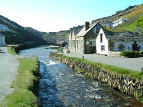 Leaving
Tintagel I then made my way into Boscastle to find the Youth Hostel which was
originally the stable for the horses which pulled the boats up onto the quay.
This is a lovely hostel right on the edge of the harbour wall.
I spent some time down by the harbour writing today’s postcard and
watching some children playing in the water and just generally relaxing.
I then went for a walk in the village hoping to find a shop to sell me
something for breakfast. I had left
it too late – being a Saturday everyone had closed up shop for the day.
Oh well – never mind – breakfast will have to be very similar to my
tea tonight. They don’t make Youth
Hostels like they did in the good old days with a shop where you can buy 1 egg,
2 weetabix etc. I guess there are
too many corner shops open all hours – and anyway – people, more often than
not, arrive in their cars with their cool-boxes and provisions, cycles on top or
boots and rucksacks in the back. The
traditional cyclist and walker are few and far between.
At least the hostel provided me with a free cup of coffee.
Leaving
Tintagel I then made my way into Boscastle to find the Youth Hostel which was
originally the stable for the horses which pulled the boats up onto the quay.
This is a lovely hostel right on the edge of the harbour wall.
I spent some time down by the harbour writing today’s postcard and
watching some children playing in the water and just generally relaxing.
I then went for a walk in the village hoping to find a shop to sell me
something for breakfast. I had left
it too late – being a Saturday everyone had closed up shop for the day.
Oh well – never mind – breakfast will have to be very similar to my
tea tonight. They don’t make Youth
Hostels like they did in the good old days with a shop where you can buy 1 egg,
2 weetabix etc. I guess there are
too many corner shops open all hours – and anyway – people, more often than
not, arrive in their cars with their cool-boxes and provisions, cycles on top or
boots and rucksacks in the back. The
traditional cyclist and walker are few and far between.
At least the hostel provided me with a free cup of coffee.
I
tried for another sunset picture later in the evening – the clouds on the
horizon were beginning to clear but unfortunately the picture was not to be.
The clouds got in the way just as the sun was setting.
Today’s
mileage was 49.3 at an average of 8.7 mph. This
brings the total mileage up to 102.3
Next Chapter Return to Tony's Home Page
 The
town of
The
town of 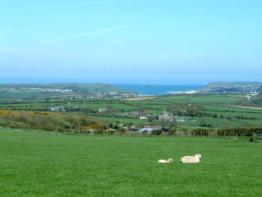 I wasn’t looking forward
to 12 miles of main road but the alternative is to go up onto the moor to the
east. It wasn’t too bad in the
end. I avoided some of this road by
going through the
I wasn’t looking forward
to 12 miles of main road but the alternative is to go up onto the moor to the
east. It wasn’t too bad in the
end. I avoided some of this road by
going through the  Leaving
Tintagel I then made my way into Boscastle to find the Youth Hostel which was
originally the stable for the horses which pulled the boats up onto the quay.
This is a lovely hostel right on the edge of the harbour wall.
I spent some time down by the harbour writing today’s postcard and
watching some children playing in the water and just generally relaxing.
I then went for a walk in the village hoping to find a shop to sell me
something for breakfast. I had left
it too late – being a Saturday everyone had closed up shop for the day.
Oh well – never mind – breakfast will have to be very similar to my
tea tonight. They don’t make Youth
Hostels like they did in the good old days with a shop where you can buy 1 egg,
2 weetabix etc. I guess there are
too many corner shops open all hours – and anyway – people, more often than
not, arrive in their cars with their cool-boxes and provisions, cycles on top or
boots and rucksacks in the back. The
traditional cyclist and walker are few and far between.
At least the hostel provided me with a free cup of coffee.
Leaving
Tintagel I then made my way into Boscastle to find the Youth Hostel which was
originally the stable for the horses which pulled the boats up onto the quay.
This is a lovely hostel right on the edge of the harbour wall.
I spent some time down by the harbour writing today’s postcard and
watching some children playing in the water and just generally relaxing.
I then went for a walk in the village hoping to find a shop to sell me
something for breakfast. I had left
it too late – being a Saturday everyone had closed up shop for the day.
Oh well – never mind – breakfast will have to be very similar to my
tea tonight. They don’t make Youth
Hostels like they did in the good old days with a shop where you can buy 1 egg,
2 weetabix etc. I guess there are
too many corner shops open all hours – and anyway – people, more often than
not, arrive in their cars with their cool-boxes and provisions, cycles on top or
boots and rucksacks in the back. The
traditional cyclist and walker are few and far between.
At least the hostel provided me with a free cup of coffee.