Previous Chapter Return to Tony's Home Page
Day 19
Wednesday 12th May 2004
Ballater
to Grantown on Spey
The
weather forecast for today looks promising but when I left Ballater it was
overcast so I decided to put some warmer clothing on. I did the right thing
because it was quite chill going up the valleys to begin with.
Before I left I decided to give ScotRail another ring.
The faxing of authorisation through to Perth had worked without a hitch
– maybe they could do the same for the tickets for the Wick to Perth travel.
They couldn’t do this to Wick as I said earlier, but tomorrow I would
be cycling close to Inverness so maybe they could fax the authorisation there.
They said they would. I then
stocked up at Alldays and started the trek to Tomintoul 24 miles away.
Today there were several hills with arrow signs on the map.
Yesterday there were two up arrows near the Devil’s Elbow on one long
climb. Today there are a total of 4
up arrows on three separate climbs.
One
thing I have noticed on my ride through the
Highlands
is the number of motorbikes. There
are also many road signs advising motorists (and cyclists?) to beware of
motorbikes and for motorbikes to drive carefully– some of the signs being in
German. Not that I have anything
against German motorcyclists – as many that I saw came from other countries in
Europe
. The bikers seem to like charging
around the open countryside, engines revving, speed limits being broken, with a
general disregard for all other road users.
Well – perhaps it was only a few of them but it resulted in me taking a
dislike to all of them. Here was I
trying to enjoy the solitude and the peacefulness of the
Highlands
, and here they were disturbing all the wildlife and creating loads of noise.
Enough of this grumble!
At 9
miles I passed over the first of these summits close to Cairn a’ Bhacain in
the Grampians. It was then a long
way down to Corgarff and the castle here which looked a very modern structure.
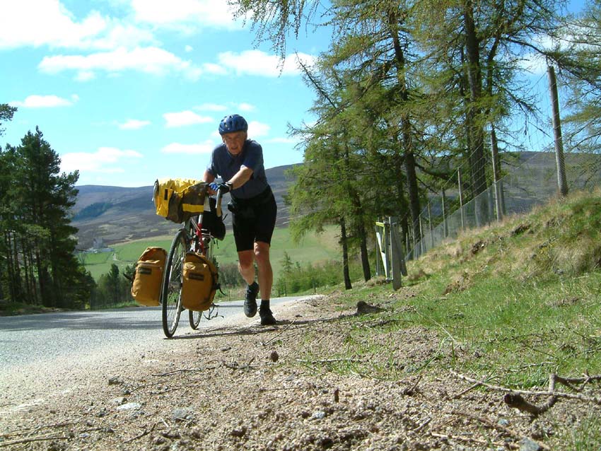
Shortly afterwards I began the second climb of the day at Co ck Bridge.
The first section of this climb was particularly steep – the sign said
20% for 450 yards. It continued well
after that but at a lesser gradient still too steep to ride though.
Just as I thought I’d reached the top another hill unfolded in front of
me. It was probably 3 miles long in
total and both sections were marked with arrows.
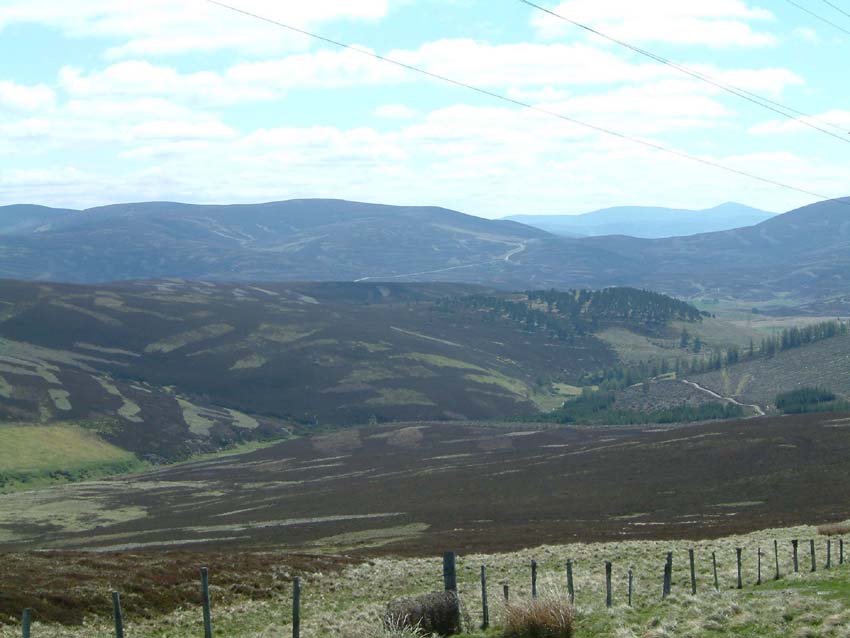
At the top was Lecht ski area close to Cairn Ealasaid – lots of ski
lifts and ski runs but no snow. Crossing
over into the county of Moray I then began an 8 mile downhill section all the
way into Tomintoul. With all the
uphill climbing I had taken my jacket off – but with the long descent it now
became quite cold and I had to button up tight to keep the wind out even though
the sun was shining brightly. It was
time for lunch, there was a nice picnic spot with benches just outside Tomintoul
and so I made myself at home.
ck Bridge.
The first section of this climb was particularly steep – the sign said
20% for 450 yards. It continued well
after that but at a lesser gradient still too steep to ride though.
Just as I thought I’d reached the top another hill unfolded in front of
me. It was probably 3 miles long in
total and both sections were marked with arrows.
At the top was Lecht ski area close to Cairn Ealasaid – lots of ski
lifts and ski runs but no snow. Crossing
over into the county of Moray I then began an 8 mile downhill section all the
way into Tomintoul. With all the
uphill climbing I had taken my jacket off – but with the long descent it now
became quite cold and I had to button up tight to keep the wind out even though
the sun was shining brightly. It was
time for lunch, there was a nice picnic spot with benches just outside Tomintoul
and so I made myself at home.
There
wasn’t much in Tomintoul to look at so I co ntinued to the Bridge of Avon and
the Bridge of
Brown
where the third ascent started but fortunately there was a café here where I
bought a pot of tea and managed to find a postcard of the area.
At the top of the climb I sat down to admire the views and to write my
postcard. There were glorious views
to the south and West over the Spey
Valley
and on to the Cairngorms. The lambs
and sheep were baaing in the field below me.
A cuckoo was cuckooing and the birds were singing.
The sky was cloudless. Absolute bliss!
I wished Christine was there to share it with me.
ntinued to the Bridge of Avon and
the Bridge of
Brown
where the third ascent started but fortunately there was a café here where I
bought a pot of tea and managed to find a postcard of the area.
At the top of the climb I sat down to admire the views and to write my
postcard. There were glorious views
to the south and West over the Spey
Valley
and on to the Cairngorms. The lambs
and sheep were baaing in the field below me.
A cuckoo was cuckooing and the birds were singing.
The sky was cloudless. Absolute bliss!
I wished Christine was there to share it with me.
I
then started the last descent of the day into Grantown in Spey and stopped on
the outskirts to sit beside the Spey by the old bridge at Grantown which is no
longer open to traffic. I was amazed
to see so many flies hovering over the river – it was swarming with them.
Where were all the swallows and martins to come and feast on them?
I had seen swallows all the way but there were none at this spot.
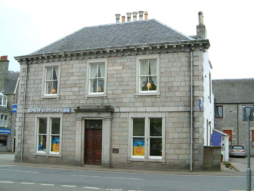
The
B&B landlady had given me very precise directions on how to find her.
The address was Bank House. When
I got to the town I was to turn right, continue up the main street until I
reached the Royal Bank of Scotland, turn left and she was first on the left. I
followed these directions – but could I find Bank House.
I made a circuit of the centre of the town passing the Royal Bank of Scotland
on two occasions. In the end I went
into the Information Bureau and asked – The reply was “It is the house which
sits on top of the Royal Bank of Scotland”! I had completely missed the
courtyard at the rear of the bank thinking this was part of the bank.
Her directions had been perfect – she might have added that her house
was on top of the bank!
the main street until I
reached the Royal Bank of Scotland, turn left and she was first on the left. I
followed these directions – but could I find Bank House.
I made a circuit of the centre of the town passing the Royal Bank of Scotland
on two occasions. In the end I went
into the Information Bureau and asked – The reply was “It is the house which
sits on top of the Royal Bank of Scotland”! I had completely missed the
courtyard at the rear of the bank thinking this was part of the bank.
Her directions had been perfect – she might have added that her house
was on top of the bank!
Today
I have cycled 41.1 miles at an average of 8.5 mph.
This now brings my total mileage to 940.6
Next Chapter Return to Tony's Home Page
 ck Bridge.
The first section of this climb was particularly steep – the sign said
20% for 450 yards. It continued well
after that but at a lesser gradient still too steep to ride though.
Just as I thought I’d reached the top another hill unfolded in front of
me. It was probably 3 miles long in
total and both sections were marked with arrows.
At the top was Lecht ski area close to Cairn Ealasaid – lots of ski
lifts and ski runs but no snow. Crossing
over into the county of Moray I then began an 8 mile downhill section all the
way into Tomintoul. With all the
uphill climbing I had taken my jacket off – but with the long descent it now
became quite cold and I had to button up tight to keep the wind out even though
the sun was shining brightly. It was
time for lunch, there was a nice picnic spot with benches just outside Tomintoul
and so I made myself at home.
ck Bridge.
The first section of this climb was particularly steep – the sign said
20% for 450 yards. It continued well
after that but at a lesser gradient still too steep to ride though.
Just as I thought I’d reached the top another hill unfolded in front of
me. It was probably 3 miles long in
total and both sections were marked with arrows.
At the top was Lecht ski area close to Cairn Ealasaid – lots of ski
lifts and ski runs but no snow. Crossing
over into the county of Moray I then began an 8 mile downhill section all the
way into Tomintoul. With all the
uphill climbing I had taken my jacket off – but with the long descent it now
became quite cold and I had to button up tight to keep the wind out even though
the sun was shining brightly. It was
time for lunch, there was a nice picnic spot with benches just outside Tomintoul
and so I made myself at home.